Foram encontradas 110 questões.
Maria não come nem peixe nem espinafre. Sarita não come nem peixe nem feijão verde. Estevão não come camarões nem batatas. Alice não come carne nem tomate. João não come peixe nem tomate. Você vai dar uma festa para essas pessoas. Dentre os pratos:
1 feijão verde 4 galinha assada
2 peixe frito 5 alface
3 carne assada 6 aipo
aqueles que podem ser servidos no jantar de forma a agradar a todos os convidados são:
Provas
Provas
A República da Algebraica criou um novo sistema de numeração que acrescenta três novos símbolos à nossa escala decimal. Dessa forma seu sistema de numeração fica:
![]()
Sabendo que o nosso número 20 é representado por 1Y e o número 100 é representado por 77, o valor do quadrado de 1 X na notação da Algebraica é:
Provas
Provas
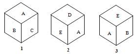
A figura abaixo mostra três visões de um mesmo cubo. Sabendo-se que cada letra significa uma cor diferente, a cor da face oposta à da face marcada com A, na vista 1, é:
Provas
Na soma de três parcelas mostrada abaixo, cada letra representa um dígito numérico distinto:
![]()
Sabendo-se que A, D e G são diferentes de zero, o valor de J é:
Provas
É feito um furo cilíndrico de 6 cm de comprimento, que passa pelo centro de uma esfera e a atravessa completamente. O volume restante na esfera, em centímetros cúbicos, é de:
Provas
Provas
TEXT II
WHAT IS OPEN GIS?
As costs of computer hardware and software for geographic information systems (GIS) decline, resource managers are paying increasing attention to maximizing the value of environmental data. Much work to date has been done in the areas of standardized data development, distribution of digital information, and format translation. Less effort has been directed toward the exchange of information between inventory-based GIS applications and analytical tools such as statistical analysis, process modeling, and pattern recognition. Future success of GIS as a technology and as a paradigm of spatial understanding will depend on the seamless integration of diverse methods into a comprehensive system for scientific investigation and environmental planning.
The open systems model is an approach to software engineering and system design that enables and encourages sharing of data, resources, tools, and so forth between different users or applications. When applied to the domain of geographic information systems, the intent is to move away from the current paradigm in which specific GIS applications and capabilities are tightly coupled to their internal models and structures. Open GIS facilitates exchange of information not only between individual GISs but also to other systems, such as statistical analysis, image processing, document management, or visualization.
(http://www.regis.berkeley.edu/gardels/envmodel.html)
current in “current paradigm” means:
Provas
TEXT II
WHAT IS OPEN GIS?
As costs of computer hardware and software for geographic information systems (GIS) decline, resource managers are paying increasing attention to maximizing the value of environmental data. Much work to date has been done in the areas of standardized data development, distribution of digital information, and format translation. Less effort has been directed toward the exchange of information between inventory-based GIS applications and analytical tools such as statistical analysis, process modeling, and pattern recognition. Future success of GIS as a technology and as a paradigm of spatial understanding will depend on the seamless integration of diverse methods into a comprehensive system for scientific investigation and environmental planning.
The open systems model is an approach to software engineering and system design that enables and encourages sharing of data, resources, tools, and so forth between different users or applications. When applied to the domain of geographic information systems, the intent is to move away from the current paradigm in which specific GIS applications and capabilities are tightly coupled to their internal models and structures. Open GIS facilitates exchange of information not only between individual GISs but also to other systems, such as statistical analysis, image processing, document management, or visualization.
(http://www.regis.berkeley.edu/gardels/envmodel.html)
The tense in “has been directed” refers to a:
Provas
Caderno Container